Globally, to this date – 15th of April – the coronavirus pandemic has spread to more than 2 million people and killed 127,168. In four months, the novel virus has occupied global consciousness and changed our day-to-day life almost all over the world.
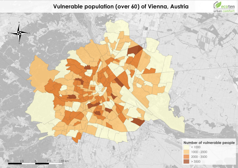
Considering the hardship humanity is currently facing, we have decided to share with the city of Madrid a way to identify areas with high densities of adults over 65: a high-risk population according to the C.D.C. (Centers for Disease Control and Prevention). Older adults, as well as people who have severe underlying chronic medical conditions, are at higher risk for developing more serious complications from COVID-19.
At ECOTEN, we are convinced that protecting society’s most vulnerable is essential. As part of our Urban Heat Vulnerability assessment for cities, we identify and process the vulnerable populations using satellite imagery and demographic data. In response to the pandemic, we felt we had to take action by sharing our insights and providing our COVID-19 Sensitivity Maps to allow decision-makers to know more precisely where to locate temporary emergency services.
Testing sites, medical services, and food distribution centers can now be located in areas where the most vulnerable people – often the least mobile – can reach more easily at times of possible lockdowns, quarantines, public transport disruptions, and where first responders may be needed the most.
The more scientists know about the virus, the better we can determine at-risk populations criterias. Relying on data that cities can provide us with, we could identify accurately and distinguish the different vulnerable groups towards COVID-19.
To know more about what we could do for your city, please contact us at info@urban-comfort.eu.